Gain a deeper understanding of your waterbody with Wisconsin Lake and Pond Resource's advanced lake mapping services. Explore how bathymetric surveys, aquatic vegetation mapping, and habitat assessments can help optimize your lake and pond management.
Lake mapping is a powerful tool used to assess and manage aquatic ecosystems. At Wisconsin Lake and Pond Resource, we utilize state-of-the-art technology, including BioBase mapping software, to gather precise data about water depth, plant growth, and underwater habitat structures. These valuable insights help us craft customized management strategies tailored to the specific needs of your pond or lake.
By providing a detailed picture of what's happening beneath the surface, mapping allows us to make informed decisions to address common challenges, such as invasive aquatic weeds, poor water quality, or underperforming fish populations.
What Is Lake Mapping?
Lake mapping involves gathering detailed spatial data to analyze underwater features and aquatic conditions. The three most common surveys we conduct are:
- Bathymetric Surveys: Measuring water depth and underwater contours
- Aquatic Vegetation Mapping: Identifying plant species, density, and distribution
- Fish Habitat Assessments: Locating fish habitats, submerged structures, and areas requiring improvement
The data from these surveys creates visual maps that provide clarity and actionable insights to manage and protect your waterbody.
How Wisconsin Lake and Pond Resource Uses Mapping to Enhance Lake and Pond Management
1. Aquatic Vegetation Management
Aquatic weed control is a top priority for many lake and pond owners. Through vegetation mapping, we can:
- Identify areas with dense or invasive plant growth
- Measure the extent of surface and subsurface vegetation
- Apply treatments like herbicides or mechanical removal in the most effective zones
- Track vegetation control progress with follow-up mapping surveys
This precise approach reduces unnecessary chemical applications and helps focus treatment on areas that need it most, ensuring better results.
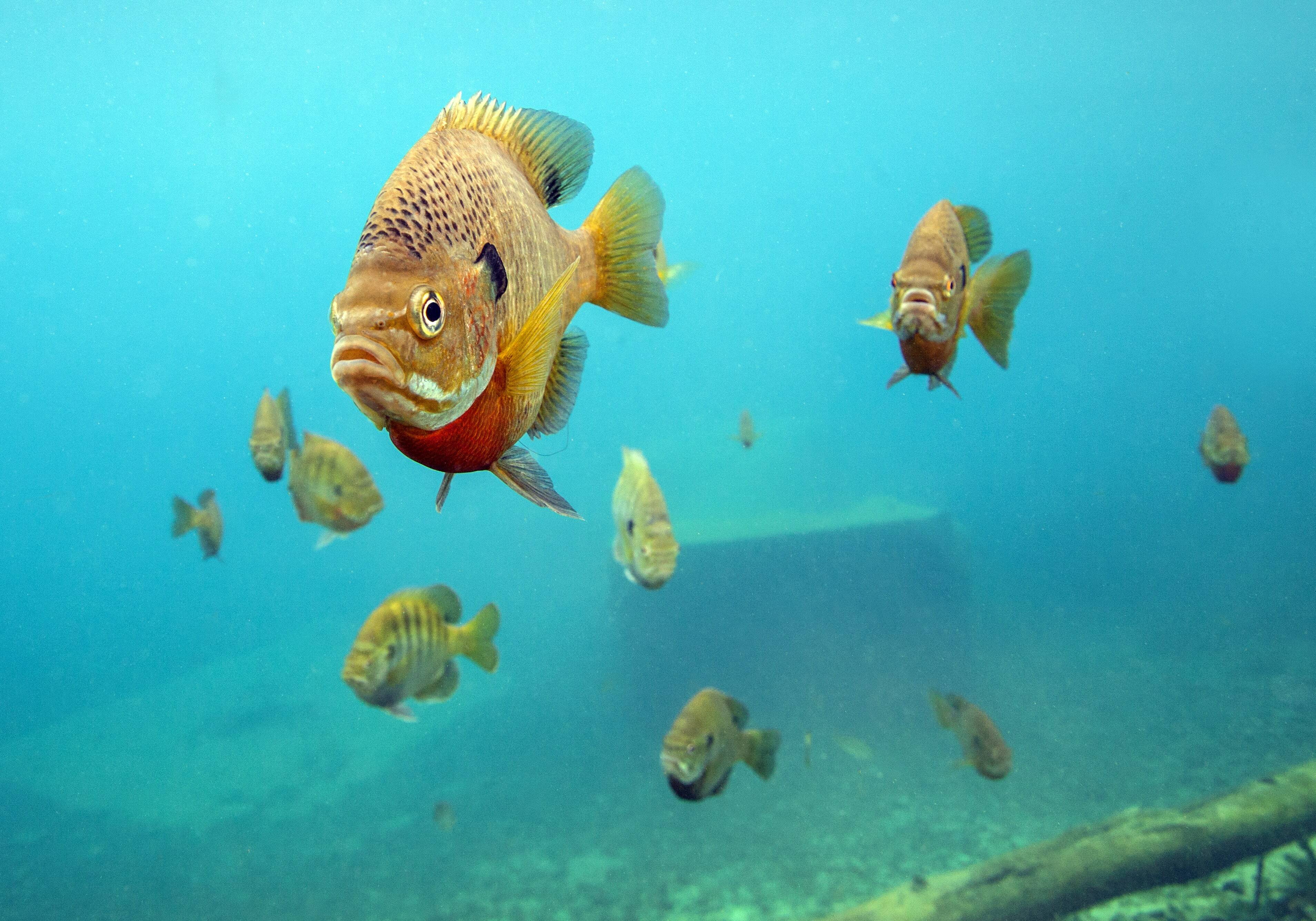
2. Fish Habitat and Stocking Plans
Proper fish stocking and habitat management are essential for a thriving aquatic ecosystem. Using lake mapping, we can:
- Identify optimal fish stocking sites based on water depth and structure
- Locate shallow areas that may lack oxygen or suitable habitats for fish
- Monitor seasonal habitat changes to adjust stocking strategies
- Support healthy predator-prey dynamics by locating ideal forage fish zones
With mapping, we can develop a comprehensive stocking plan and habitat enhancement strategy tailored to the needs of your fish population.
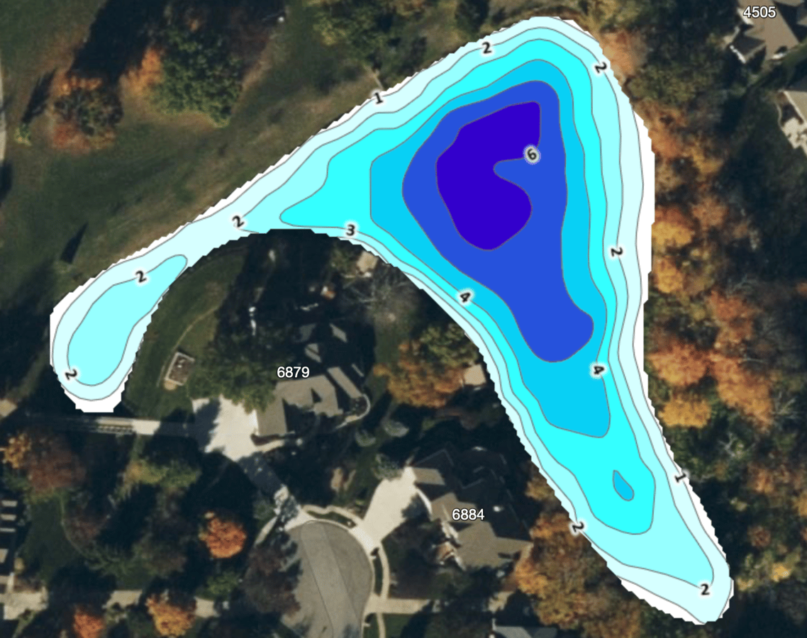
3. Bathymetric Surveys and Sediment Management
Sedimentation can have long-term impacts on lake health. Our bathymetric surveys help:
- Measure changes in water depth and sediment buildup over time
- Identify shallow zones that can negatively affect water quality
- Plan for necessary dredging or sediment removal to restore depth
- Estimate water volume for aeration system sizing and chemical treatments
Tracking bathymetric data over time helps us understand the sedimentation process and plan for proactive maintenance to preserve water quality and ecological balance.
4. Clear Communication with Lake Associations and Stakeholders
Mapping makes it easier to communicate complex issues in a visually appealing and understandable way. By using detailed, color-coded maps, property managers, lake associations, and stakeholders can easily see:
- Before-and-after treatment comparisons
- Areas with high aquatic vegetation or sediment buildup
- Key zones needing improvement, such as erosion or low oxygen areas
This transparency builds trust and helps ensure all parties are aligned in managing the waterbody effectively.


Why Lake Mapping Is Essential for Long-Term Lake Health
At Wisconsin Lake and Pond Resource, we believe that mapping is integral to maintaining the long-term health of your waterbody. By incorporating detailed mapping into your management strategy, we can:
- Identify issues early for prompt action
- Allocate resources more efficiently
- Ensure transparency with stakeholders
- Track progress over time to refine management efforts
Whether you're managing a private lake, a community water feature, or a recreational pond, lake mapping provides essential data to make informed decisions that support your goals.
Ready to optimize your lake or pond management? Contact Wisconsin Lake and Pond Resource today to schedule a bathymetric survey, vegetation mapping, or fish habitat assessment and start managing your waterbody with confidence.
About Wisconsin Lake & Pond Resource, A Jones Lake Management Partner
Wisconsin Lake & Pond Resource specializes in comprehensive lake and pond management solutions, including algae and aquatic weed control, aeration, hydraulic dredging, erosion control, and fisheries management. As a Jones Lake Management Partner, we serve a diverse range of clients, including HOAs, golf courses, municipalities, and private lake owners. With a commitment to science-driven strategies and environmental sustainability, Wisconsin Lake & Pond Resource helps maintain and restore aquatic ecosystems for long-term health and enjoyment.